


GNSS
Quelles stations GNSS ?
- Carte
- Fournisseurs GNSS
- Quelles données GNSS ?
- Accès aux données
- Quelles solutions GNSS ?
- Derniers événements
-
Cliquer sur la légende ci-dessus pour afficher/cacher un groupe de stations
Ci-dessous une liste des organismes fournisseurs de données des stations GNSS, triée par pays. A chaque fournisseur sont associées les stations pour lesquelles SONEL dispose de données. Cette liste est en cours de construction. N’hésitez pas à nous contacter pour maintenir cette liste à jour.
E-mail : sonel@sonel.org
| PAYS (58) | FOURNISSEUR (230) | SIGLE | Stations GNSS (1344) |
|---|---|---|---|
| Geospatial Information Authority of Japan | GSI | (49) | |
| Service Hydrographique et Océanographique de la Marine | SHOM | (6) | |
| National Oceanic and Atmospheric Administration | NOAA | (13) | |
| Instituto Geografico Nacional | IGNE | (44) | |
| Institut Polaire Français Paul Emile Victor | IPEV | (4) | |
| Geoscience Australia | GA | (77) | |
| Puertos del Estado | PDE | (10) | |
| University of Hawai'i Sea Level Centre | UHSLC | (12) | |
| UNAVCO | UNAVCO | (92) | |
| Delft University of Technology | TUDELFT | (4) | |
| Istituto Nazionale di Geofisica e Volcanologia | INGV | (14) | |
| Instituto Geografica Nacional de la Republica Argentina | IGNRA | (5) | |
| Korea Astronomy and Space Science Institute | KASI | (5) | |
| Instituto de Geofísica - Servicio Mareográfico Nacional - UNAM | SMN-UNAM | (17) | |
| Laboratoire de Géologie de l’Ecole normale supérieure | GEOL-ENS | (3) | |
| Instituto Nacional de Estadística y Geografía | INEGI | (6) | |
| Bundesanstalt für Gewässerkunde | BAFG | (46) | |
| Institut de Physique du Globe de Paris | IPGP | (5) | |
| Centro GNSS de Canarias | CGC | (1) | |
| Agenzia Spaziale Italiana | ASI | (9) | |
| Centre d'Etudes Techniques Maritimes et Fluviales | CETMEF | (7) | |
| National Oceanography Centre | NOC | (9) | |
| Instituto de Estadística y Cartografía de Andalucía | IECA | (6) | |
| Gipuzkoako Foru Aldundia | GFA | (1) | |
| National Mapping and Resource Information Authority | NAMRIA | (23) | |
| Instituto Brasileiro de Geografia e Estatística | IBGE | (21) | |
| Korea Hydrographic and Oceanographic Administration | KHOA | (8) | |
| National Geo-Spatial Information | NGI | (10) | |
| Réseau National GPS permanent | RENAG | (16) | |
| Norwegian Mapping Authority - Kartverket | NMA | (21) | |
| Deutsches Geodätisches Forschungsinstitut | DGFI | (2) | |
| DTU Space National Space Institute | DTU-Space | (14) | |
| LIENSs - OASU | LIENSs-OASU | (22) | |
| Centre National de la Recherche Scientifique | CNRS | (20) | |
| ASG-EUPOS | ASG-EUPOS | (5) | |
| U.S. Coast guard | USCG | (39) | |
| Jet Propulsion Laboratory | JPL | (50) | |
| Bundesamt für Kartographie und Geodäsie | BKG | (21) | |
| Ordnance Survey Ireland | OSI | (6) | |
| Departamento de Geofísica, Centro Sismologico Nacional, Univ. de Chile | DGF-CSN | (1) | |
| Department of Survey and Mapping Malaysia | JUPEM | (6) | |
| Louisiana State University - Center for GeoInformatics | LSU-C4G | (6) | |
| North Carolina Geodetic Survey | NCGS | (7) | |
| Connecticut Department of Transportation | CT-CONDOT | (1) | |
| SmartNet North America | SMRTNT | (10) | |
| Alabama Department of Transportation - Alabama Great Seal | ALDOT | (2) | |
| Texas Department of Transportation | TxDOT | (4) | |
| NYS Spacial Reference Network | NYSDOT | (1) | |
| Indian Space Research Organisation - Telemetry Tracking and Command Network | ISTRAC-ISRO | (3) | |
| Instituto Geografico Agustin Codazzi | IGAC | (3) | |
| Institut Cartografic i Geologic de Catalunya | ICGC | (1) | |
| TERIA | TERIA | (23) | |
| Massachusetts Department of Transportation | MassDOT | (3) | |
| Maine Department of Transportation | MaineDOT | (2) | |
| Virginia Department of Transportation | VDOT | (1) | |
| State of Alaska, Department of Transportation Central Region Survey Section | AK-DOT | (2) | |
| Geological Survey of Canada | GSC | (14) | |
| Japan Aerospace Exploration Agency | JAXA | (1) | |
| Instituto Geografico Nacional Tommy Guardia | IGNTG | (2) | |
| Ordnance Survey Geodesy and Positioning | OS | (38) | |
| Kadaster | NSGI | (11) | |
| Diputacion Foral de Vizcaya | DFV | (2) | |
| Real Instituto y Observatorio de la Armada | RIOA | (3) | |
| Servicio de Informacion Territorial de las Islas Baleares | SITIB | (2) | |
| GRAFCAN | GRAFCAN | (7) | |
| Observatoire de Recherche Méditerranéen de l'Environnement | OREME | (2) | |
| Puerto Rico Seismic Network | PRSN-UPRM | (6) | |
| Lamont-Doherty Earth Observatory | LDEO | (2) | |
| EarthScope Consortium | EC | (6) | |
| Institute of Astronomy University of Latvia | LUAI | (1) | |
| INSTITUTO GEOGRAFICO MILITAR Uruguay | IGM-Ur | (3) | |
| Queensland Department of Environment and Science | DESI-QLD | (11) | |
| NSW Spatial Services | NSW-SS | (13) | |
| German Aerospace Center | DLR | (1) | |
| Nationaal Geografisch Instituut | NGI | (1) | |
| Maritieme Dienstverlening en Kust | MDK | (1) | |
| Chalmers University of Technology | CUT | (1) | |
| Onsala Space Observatory | OSO | (1) | |
| Badan Informasi Geospasial | BIG | (14) | |
| Department of Transport and Main Roads QLD | TMR - QLD | (6) | |
| Department of Natural Resources and Mines, Manufacturing, and Regional and Rural Development - Queensland | NRMMRRD-QLD | (2) | |
| Department of Transport and Planning - Victoria | DTP-VIC | (1) | |
| Marine Institute | MI | (2) | |
| Agency for Data Supply and Infrastructure | SDFI | (23) | |
| Instituto Geofisico de Escuela Politécnica Nacional | IGEPN | (4) | |
| Centro Sismologico Nacional | CSN | (13) | |
| The Canadian High Arctic Ionospheric Network | CHAIN | (1) | |
| Laboratoire de l'Atmosphère et des Cyclones | LACY | (1) | |
| Digitaal Vlaanderen | DV | (7) | |
| British Columbia Active Control System | BCACS | (3) | |
| National Observatory of Athens | NOA | (6) | |
| South Carolina Geodetic Survey | SCGS | (3) | |
| National Park Service | NPS | (3) | |
| Institut Cartogràfic Valencià | ICV | (1) | |
| Ultimate Positionning Group | UPG | (6) | |
| RTK NetWest | RTK NetWest | (1) | |
| Observatoire des Sciences de la Réunion | OSU-R | (1) | |
| Direction Affaires Foncières | DAF | (1) | |
| Michigan State University | MSU | (1) | |
| Hilcorp Energy Company | HEC | (2) | |
| ARG | Estacion Astronomica Rio Grande | EARG | (3) |
| AUS | Department of Environment & Primary Industries | DEPI | (3) |
| AUS | LANDGATE | LANDGATE | (5) |
| AUS | Department Infrastructure, Planning & Logistics | DIPL | (2) |
| AUS | IPS Radio and Space Services - Australia Bureau of Meteorology | IPS | (1) |
| AUS | Australian Surveying & Land Information Group | AUSLIG | (1) |
| AUS | Curtin University | Curtin University | (1) |
| BEN | Institut Geographique National du Benin | IGN-BJ | (1) |
| BOL | INSTITUTO GEOGRAFICO MILITAR DE BOLIVIA | IGM-Bo | (1) |
| BRA | Instituto Nacional de Pesquisas Espaciais | INPE | (1) |
| BRB | Coastal Zone Management Unit | CZMU | (2) |
| CAN | National Resources Canada | NRCan | (30) |
| CAN | SERVICE NOVA SCOTIA | SNS | (4) |
| CAN | Dept. Internal Services | ISD | (1) |
| CHE | Swiss Federal Office of Topography | SWISSTOPO | (1) |
| CHL | Center for Space Studies | CEC | (2) |
| CHL | Universidad de Concepcion | UdeC | (1) |
| CHL | Universidad de Antofagasta | UANTOF | (1) |
| CHL | Universidad de Santiago de Chile | USACH | (1) |
| COL | Servicio Geologico Colombiano | SGC | (1) |
| CPV | Instituto Nacional de Meteorologia e Geofisica | INMG | (1) |
| CRI | Registro Nacional Republica Costa Rica | RNP | (3) |
| CYM | Cayman Land Info | CAYMAN | (1) |
| DEU | Deutsches GeoForschungsZentrum | GFZ | (21) |
| DNK | Danish Geodata Agency | GST | (1) |
| DOM | Universidad Nacional Pedro Henriquez Ureña | UNPHU | (3) |
| ECU | Instituto Geografico Militar Ecuador | IGM_EC | (2) |
| EGY | Centre d'Etudes Alexandrines | CEAlex | (2) |
| ESP | Instituto Espanol de Oceanografia | IEO | (1) |
| ESP | Geodetic Department Universtidad de Cantabria | UC | (1) |
| ESP | Department of Applied Geodesy - Aranzadi Society of Sciences | ADAG | (1) |
| EST | Estonian Land Board | ELB | (15) |
| FIN | Finnish Geospatial Research Institute, National Land Survey of Finland | FGI-NLS | (5) |
| FRA | Institut National de l'Information Géographique et Forestière | IGN | (39) |
| FRA | Laboratoire d'Etudes en Geophysique et Oceanographie Spatiale | LEGOS | (10) |
| FRA | Direction des Infrastructures, de la Topographie et des Transports Terrestres | DITTT | (8) |
| FRA | Port Autonome de Nantes - Saint-Nazaire | PANSN | (1) |
| FRA | Centre National d"Etudes Spatiales | CNES | (23) |
| FRA | ORPHEON | ORPHEON | (1) |
| FRA | ACTIPLAN SARL | ACTIPLAN | (4) |
| FRA | SATINFO Réseau GNSS | SAT-INFO | (10) |
| FRA | GIE Coop&Tech - Réseau RTK - Groupement de Cooperatives Agricoles | GIE Coop&Tech | (3) |
| FRA | Ville de Nice | Ville de Nice | (1) |
| FRA | Grand Port Maritime du Havre | HAROPA | (3) |
| FRA | Communauté Urbaine de Dunkerque | CUD | (1) |
| FRA | Ville de Cannes - Direction des systèmes d'information Géographique | Ville de Cannes | (3) |
| FRA | Ecole Normale Superieure / CNRS - Laboratoire de Geologie | ENS-GEOLOLOGIE | (1) |
| FRA | IPG - Observatoire volcanologique du Piton de la Fournaise | IPG | (1) |
| FRA | DTAM - Phares et Balises | DTAM | (2) |
| FRA | Météo France | MF | (1) |
| FRA | Grand Port Maritime de Nantes | GPMN | (1) |
| FRA | Service des Phares et Balises de Guyane | DM-GUYANE | (2) |
| FRA | Institut National de l'Information Géographique et Forestière | IGN | (1) |
| FRA | GéoAzur - Observatoire de la Cote d'Azur | GeoAzur - OCA | (1) |
| FRA | Conseil départementale des Pyrénées Atlantiques | CDPA | (1) |
| GBR | NERC British Isles continuous GNSS Facility | BIGF | (14) |
| GBR | Bermuda Institute of Ocean Science | BIOS | (1) |
| GBR | European Space Agency | ESA | (1) |
| GRC | DEPARTMENT of GEODESY & SURVEYING | DGS | (1) |
| GRC | National Technical University of Athens | NTUA | (1) |
| GRC | Hellenic National Tsunami Warning Centre | HL-NTWC | (1) |
| GRC | Technical University of Crete | TUC | (3) |
| HKG | Lands Department - Hong-Kong | LD-HK | (12) |
| HRV | Hydrographic Institute of the Republic of Croatia | HHI | (1) |
| HRV | State Geodetic Administration | SGA | (4) |
| IDN | National Coordination Agency for Surveys and Mapping | BAKOSURTANAL | (2) |
| IRN | National Cartographic Center of I.R.IRAN | NCC | (1) |
| ISR | Survey of Israel (SOI) | SOI | (2) |
| ITA | Università degli Studi di Ferrara | UNIFE | (1) |
| ITA | Consiglio Nazionale delle Ricerche - Istituto di Scienze Marine | CNR- ISMAR | (3) |
| ITA | Regione Campania | RC | (1) |
| ITA | Regione Abruzzo | RAbruzzo | (1) |
| ITA | Cooperativa San Martino | COOPSM | (1) |
| ITA | e-geos S.p.A. - una societa ASI/Telespazio | TPZ | (3) |
| ITA | INAF ASTRONOMICAL OBSERVATORY OF CAGLIARI | CAO | (1) |
| ITA | Universita' di Cagliari - Dip. Ingegneria Strutturale - Sez. Topografia | DISIG-Cagliari | (1) |
| KOR | National Geographic Information Institute | NGII | (1) |
| LKA | Surveyor General's Office Colombo | SGOC | (1) |
| LTU | Geodetic Institute of Vilnius TU | VGTU GI | (1) |
| LUX | University of Luxembourg | UL | (5) |
| LVA | Latvijas Geotelpiskas Informacijas Agentura | LGIA_LatPOS | (2) |
| MDG | Institute Observatory of Geophysics of Antananarivo | IOGA | (1) |
| MDV | Gan Meteorological Office | GANMET | (1) |
| MEX | Instituto Municipal de Investigación y Planeación de Ensenada | IMIP | (1) |
| NAM | Directorate of Survey and Mapping Namibia | DSM-NAM | (1) |
| NZL | GNS Science - GeoNet | GNS - GEONET | (26) |
| NZL | Land Information New Zealand | LINZ | (13) |
| NZL | University of Otago | uOtago | (2) |
| OMN | Petroleum Development Oman | PDO | (1) |
| PER | Instituto geografico del peru | IGN PERU | (1) |
| PHL | Naval Forces West | NFW | (1) |
| PHL | Mindanao State University | MSU | (1) |
| POL | Space Research Centre of the Polish Academy of Sciences | SRC-PAS | (1) |
| PRT | Space & Earth Geodetic Analysis Laboratory | SEGAL | (3) |
| PRT | Direccao de Servicos de Cartografia e Informacao Geografica | DSCIG | (1) |
| PRT | Direcao-Geral do Territorio | DGT | (2) |
| PYF | Université de la Polynesie francaise | UPF | (9) |
| ROU | National Institute for Earth Physics | NIEP | (2) |
| ROU | National Center for Cartography - ROMPOS Bureau | NCC - ROMPOS | (1) |
| RUS | SmartNet Russia | SMARTNET | (1) |
| RUS | Research Station of RAS | RS-RAS | (9) |
| RUS | Geophysical Observatory Arti | ARS | (1) |
| SEN | Universite Cheikh Anta Diop | UCAD | (1) |
| SEN | Direction des Travaux Geographiques et Cartographiques | ANAT/DTGC | (1) |
| SGP | Nanyang Technological University | NTU | (1) |
| SGP | Singapore Land Authority | SLA | (5) |
| SGP | Earth Observatory of Singapore | Singapore EO | (1) |
| SVN | Surveying and Mapping Authority of the Republic of Slovenia | SMARS | (1) |
| SWE | SWEPOS-LANTMÄTERIET | SWEPOS-LMV | (46) |
| TWN | National Measurement Laboratory ; Industrial Technology Research Institute | NML - ITRI | (2) |
| TWN | Institute of Earth Sciences, Academia Sinica | IES | (5) |
| TZA | Tanzania Ports Authority | TPA | (1) |
| URY | Servicio geographico militar | SGM | (2) |
| USA | National Geodetic Survey | NGS | (15) |
| USA | US Geological Survey | USGS | (12) |
| USA | University of California - Berkeley Seismological Laboratory | UC-BSL | (6) |
| USA | U.S. Naval Observatory | USNO | (4) |
| USA | National Radio Astronomy Observatory | NRAO | (5) |
| USA | University of the Virgin Islands | UVI | (2) |
| USA | Plate Boundary Observatory - EarthScope | PBO | (4) |
| USA | Federal Aviation Administration | FAA | (3) |
| USA | University of Maryland, Baltimore County | UMBC | (1) |
| USA | Washington State Reference Network | WSRN | (4) |
| USA | National Geospatial-Intelligence Agency | NGA | (7) |
| USA | CICESE Laboratorio del Nivel del Mar | CICESE | (1) |
| USA | University of Maine at Machias | UMM | (1) |
| USA | UNITED STATES AIR FORCE | USAF | (1) |
| USA | Scripps Orbit and Permanent Array Center | SOPAC | (1) |
| USA | Pacific GPS Facility - Hawaii Institute of Geophysics and Planetology - University of Hawaii at Manoa | PGF | (15) |
| USA | Florida Department of Transportation | FDOT | (10) |
| USA | The Surveyors Exchange | SUREX | (1) |
| VEN | Centro de Procesamiento y Analisis GNSS SIRGAS de LUZ | CPAGS-LUZ | (1) |
| ZAF | The Hartebeesthoek Radio Astronomy Observatory | HartRAO | (4) |
Les observations GNSS que nous diffusons se présentent sous forme de fichiers journaliers à 30s (24h d’observations cadencées à 30s) au format standard international RINEX. Plus d’infos sur les fichiers RINEX.
Outre les fichiers d’observation RINEX des stations GNSS, SONEL diffuse toute information auxiliaire permettant l’analyse fine des mesures GNSS, en particulier :
– les orbites précises de l’IGS,
– les paramètres d’orientation de la Terre de l’IGS.
Evolution du nombre de fichiers Rinex disponibles sur SONEL (par DOY) depuis 1991-079
Nombre de stations GPS en fonction de la longueur de la série de données.
Nombre cumulé de stations GPS dont la longueur de la série est au moins de x années.
Les observations GPS sont accessibles sur le serveur FTP de SONEL (ftp.sonel.org) de manière anonyme. Les conditions d’accès sont de citer la source des données dans toute communication, orale ou écrite. Plus de détails.
L’outil FileZilla est un client FTP gratuit qui permet d’accéder facilement aux données.
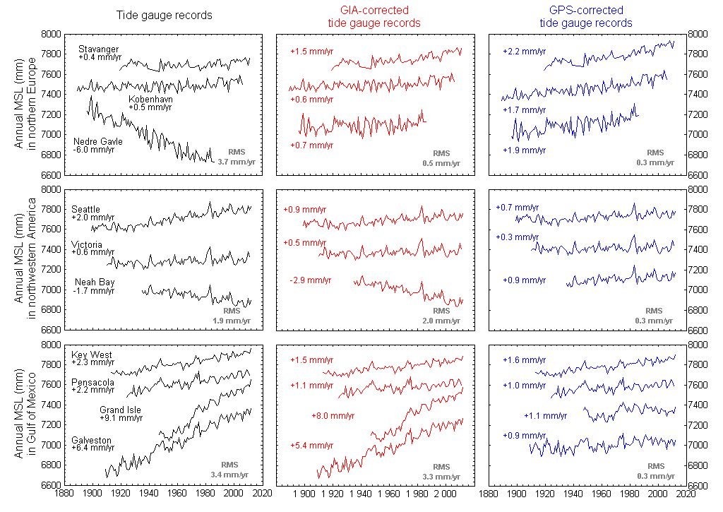
- Le traitement des observations GNSS est particulièrement complexe pour déterminer les mouvements verticaux du sol sur lequel reposent les marégraphes (mouvements de l’ordre du mm/an). L’article publié en 2007 par les membres du consortium du centre d’analyses GPS ’ULR’ explique les difficultés et les défis soulevés par cette problématique. La figure ci-contre illustre les enjeux : à gauche sont présentées des séries de niveaux moyens de la mer mesurés par marégraphie ; au milieu les séries sont corrigées avec les prédictions du modèle de rebond postglaciaire ICE5G (VM2) ; et à droite avec les vitesses GPS obtenues par le centre ’ULR’ dans le repère ITRF2008.
- Pour répondre à ce besoin SONEL s’appuie donc sur le centre d’analyses ULR dont l’infrastructure de calcul se trouve à l’université de La Rochelle. Le cluster acquis en 2008 a permis de réduire les temps de calcul de manière très significative, passant de 1 an à 2-3 semaines pour traiter 10 ans d’observations GPS d’un réseau global de quelque 200 stations. Il ouvre de très importantes perspectives d’expérimentation (nouvelles stratégies, modélisations, corrections). En particulier, il a permis au groupe ULR de concourir avec les 9 des plus prestigieux groupes du domaine du spatial à la première campagne ’reprocessing’ du service international IGS.
– La dernière solution ULR publiée dans la revue Global and Planetary Change est disponible dans SONEL sous forme de séries temporelles de positions hebdomadaires et de vitesses. Cliquez sur le lien ci-dessus pour obtenir des détails et récupérer les résultats.
| DATE EVENEMENT | TYPE D'EVENEMENT | ACRONYME | COMMENTAIRE |
|---|---|---|---|
| 2026-06-06 | New data | JPNL | 116 Rinex3 files between 2026-018 and 2026-152 |
| 2026-05-19 | New data | VIS0 | 810 Rinex2 files between 1996-310 and 2016-331 |
| 2026-05-19 | New data | CZTR | 344 Rinex3 files between 2025-099 and 2026-078 |
| 2026-04-20 | New GNSS | GVD2 | No data available for GVD2 |
| 2026-04-20 | New GNSS | GVD7 | No data available for GVD7 |
Enquête sur la colocalisation entre GNSS et marégraphes (GNSS@TG)

Dans le but d’avoir une meilleure idée de l’existence des stations GPS colocalisés aux marégraphes, des enquêtes sont menées périodiquement auprès de différentes communautés scientifiques. L’objectif est d’identifier les stations GPS existantes qui sont proches d’un marégraphe (jusqu’à une distance d’environ 10 à 15 km).
– Les résultats de l’enquête peuvent être visualisés dans la carte située en haut de la page. Les stations pour lesquelles SONEL ne dispose pas encore de mesures sont en violet.
– En cliquant sur l’image de la table à droite, une version à jour de l’ensemble des données de l’enquête s’affiche. La table peut être classée simplement en cliquant sur les en-têtes des colonnes et les informations peuvent être téléchargées dans un format (.csv) qui est compatible avec des applications telles que Excel.

– Un fichier ’.kmz’ permet de voir la distribution géographique des GPS colocalisés sur l’application Google Earth. Le contenu du fichier cgpstg.kmz est cohérent avec la table ci-dessus. Il est mis à jour toutes les semaines. En cliquant sur un symbole, vous obtiendrez des informations complémentaires sur la station. De la même façon, vous pouvez obtenir le contenu du sitelog GPS (si les mesures GPS sont disponibles). Le fichier "kmz" CGPS@TG peut être exploité en liaison avec le fichier ".kmz" des traces sol des satellites d’altimétrie radar. Ce fichier est fourni par CLS. De la même façon, il peut aussi être exploité avec le fichier ".kmz" des marégraphes disponibles au PSMSL.
– En plus des enquêtes périodiques, des informations concernant la colocalisation des GPS et des marégraphes (CGPS@TG) peuvent parvenir à tout moment à SONEL en remplissant ce formulaire (en anglais). Merci par avance pour votre précieuse collaboration.
– Le module de génération de fichier sitelog peut vous aider à générer un fichier sitelog en conformité avec la norme IGS.


